Contents — find the section you need
Background and reading guide
Background Basic terminology of the technology; consult the linked fundamentals as needed.
Trends · Read the sources, reporting period and comparison criteria together.
LiDAR-SLAM is the family of techniques that performs self-localization and mapping using the point-cloud data a laser-ranging sensor returns. Compared to Visual-SLAM, it's far less sensitive to lighting conditions and yields direct distance information — but the technical core of the problem becomes how fast and how accurately point clouds can be matched to each other (scan matching). For the fundamentals — how ICP/NDT work, why LOAM extracts features — see the "LiDAR-SLAM Primer".
 ROS 2
ROS 2Image: Robot Operating System logo, Wikimedia Commons (CC BY-SA 4.0)

LiDAR-SLAM at a Glance
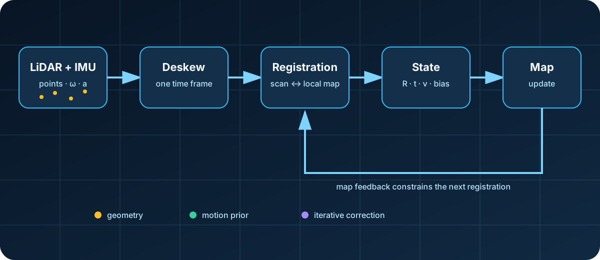
Diagram: Duskcoil. The relationships in a representative lidar-inertial SLAM pipeline are simplified.
LiDAR-SLAM is not a one-shot operation that merely overlays two point clouds. The IMU corrects distortion caused by platform motion during a scan; geometric disagreement with the local map updates pose, velocity, and sensor biases; and that estimate updates the map in turn. With this cycle in view, the LOAM, ICP/NDT, and FAST-LIO families below can be compared along three concrete questions: how correspondences are formed, how the state is updated, and how the map is stored.
The Feature-Extraction Lineage: LOAM and Its Successors
The early mainstream approach extracted geometric features — edges, planes — from the point cloud and tracked them to estimate displacement between scans (the LOAM lineage). The processing is easy to reason about, but tuning the feature-extraction parameters is fiddly, and accuracy tends to drop in feature-poor environments (a featureless corridor, for instance).
The Two Basic Scan-Matching Algorithms: ICP and NDT
At the core of LiDAR-SLAM sits the question of how to find correspondence between successive point-cloud scans, or between a scan and the map — and there are two basic algorithms this comes down to.
ICP (Iterative Closest Point) matches points between two point clouds based on distance, then iteratively estimates the rigid-body transform that minimizes the resulting alignment error. Rather than plain point-to-point matching, using a point-to-plane approach — deriving a normal vector from a point's local geometry and minimizing point-to-plane distance instead — converges faster and is less prone to local minima. Where point \mathbf{p}_i corresponds to a plane defined by normal \mathbf{n}_i and a point on the plane \mathbf{q}_i, the point-to-plane distance is
and the rotation \mathbf{R} and translation \mathbf{t} being solved for come from minimizing
There's a caveat specific to LiDAR, though: because a LiDAR point cloud is vertically sparse (arranged in layers), naively applying normal estimation across the whole point cloud degrades accuracy.
NDT (Normal Distribution Transform) takes a different approach from ICP: it divides the point cloud into a voxel grid and represents the point distribution inside each voxel as a Gaussian distribution. Rather than matching individual points directly, it optimizes the fit between these probability density functions, achieving an alignment that's less sensitive to noise.
A direct method like FAST-LIO is distinguished by sidestepping the explicit correspondence-finding step these traditional scan-matching approaches rely on entirely, instead registering the point cloud directly against the map (a voxel structure), which is what gives it its computational efficiency.
The Shift to Direct Methods: FAST-LIO/FAST-LIO2
What resolved this weakness was the "direct method" — registering a point cloud directly against the map with no explicit feature extraction step. FAST-LIO2 is the leading example, achieving high efficiency (especially on solid-state LiDARs like Livox products) through efficient nearest-neighbor search via an incremental k-d tree. newbot also adopts FAST-LIO as the core of its self-localization (see "How Self-Localization and Sensor Fusion Work" for details).
The FAST-LIO lineage has kept extending since. FAST-LIVO2 (2025, IEEE Transactions on Robotics) integrates visual information; LTA-OM, built with FAST-LIO2 as its front end, adds support for multi-session operation and dynamic map updates — the main direction of development has moved beyond standalone odometry toward long-term operation and large-scale environments.
New Developments in 2026: D-LIO and the Push Toward Lighter, More Robust Methods
2026 saw D-LIO (Direct LiDAR-Inertial Odometry) published in IEEE Robotics and Automation Letters, taking an approach distinct from the FAST-LIO lineage. It uses mapping via a truncated signed distance field, letting map updates run in constant time regardless of map size — a design that prioritizes scalability in large environments.
Beyond that, a steady stream of derivative methods have continued to appear in journals and preprint servers well into 2026: FAR-LIO, aimed at fast autonomous movement; GenZ-LIO, which handles both confirmed open and enclosed environments; Voxel-SLAM, balancing completeness and generality. The overall direction can be summed up in three points: (1) direct methods that skip feature extraction have become mainstream, (2) multi-sensor fusion across vision, LiDAR, and IMU is becoming standard, and (3) lightweighting for edge hardware with limited compute remains an important ongoing research theme.
The 2026 Speed Race: Improvements by the Numbers
The LIO derivatives published through 2026 increasingly back up their claims with concrete numbers rather than just proposing "yet another method." FAR-LIO (June 2026), a CUDA-parallelized framework aimed at autonomous racing, reports a 6.9% reduction in positional error and a 38.4% reduction in runtime versus existing methods at speeds up to 250 km/h. EllipseLIO (May 2026), which adapts to the environment using an ellipsoid representation, claims 35% lower odometry error on average than the second-best competing approach. Environment-Adaptive Solid-State LiDAR-Inertial Odometry (April 2026), which combines local normal-vector constraints with degeneracy-aware map maintenance for solid-state LiDAR, cuts RMSE by up to 12.8% in geometrically degenerate, harsh environments. These numbers aren't directly comparable across papers given differing test conditions, but all three are tackling the same underlying question: how robust can the system stay in feature-poor, degeneracy-prone environments.
Specialized Environments: Multi-Floor Navigation, Visual Fusion, and Safety
Use-case specialization is also progressing. Elevator-LIO (May 2026) addresses non-inertial motion during elevator rides (where the elevator's own acceleration corrupts IMU readings) by separately estimating the robot's motion and the elevator's motion; validated across 20 real-world sequences spanning 79 elevator rides, it achieved terminal height error below 1 cm in 17 of them. It's a concrete example of LIO's reach extending into use cases — delivery or patrol robots moving through multi-floor buildings — that standalone LIO previously struggled to handle.
In the LiDAR-inertial-visual odometry (LIVO) space, which also folds in visual information, SA-LIVO (June 2026) weights information by per-subspace reliability and shows competitive accuracy with low computational overhead on embedded hardware, benchmarked across 29 public dataset sequences. Flight-Ready LiDAR-Inertial Odometry (July 2026), built with drone deployment in mind, resolves architectural bottlenecks in existing implementations and raises the odometry output rate from 10 Hz to 200 Hz. Overall, 2026's LIO research can be summarized as specializing along four axes on top of the "direct method" foundation FAST-LIO2 established: (1) high-speed operation, (2) non-inertial and specialized environments, (3) visual fusion, and (4) high-frequency output on embedded hardware.
Why newbot Actually Chose What It Did
The deciding factor for newbot choosing FAST-LIO2 was its fit with the 6-axis IMU (angular velocity and acceleration only, no magnetometer) built into the Livox Mid-360. Methods in the LIO-SAM family, which assume a 9-axis IMU plus GTSAM, were judged a poor fit for this platform's sensor configuration. Measurement backs this up: horizontal loop-closure error came in at 1.0–1.3% of path length, decisively better than wheel odometry alone (6.9–27.4%), which suggests the choice was sound.
Does the best benchmark error identify the best method for your setting?
Sensors, motion, geometry, and compute change results. Check benchmark conditions and test speed and robustness in the target environment.
References
- FAST-LIO GitHub (hku-mars)
- D-LIO Paper (arXiv)
- FAST-LIVO2 Paper (arXiv)
- Voxel-SLAM Paper (arXiv)
- FAR-LIO Paper (arXiv)
- EllipseLIO Paper (arXiv)
- Environment-Adaptive Solid-State LiDAR-Inertial Odometry Paper (arXiv)
- SA-LIVO Paper (arXiv)
- Elevator-LIO Paper (arXiv)
- newbot's implementation is also covered in "How Self-Localization and Sensor Fusion Work"
Current step · 2 / 10 · Technology Trends
Comments
Please log in to post a comment
No comments yet.