Contents — find the section you need
Background and reading guide
Background Basic terminology of the technology; consult the linked fundamentals as needed.
Trends · Read the sources, reporting period and comparison criteria together.
SLAM (Simultaneous Localization and Mapping) is the technology behind estimating "where am I" and "what does my surroundings look like" at the same time, using nothing but sensors. This article surveys the broader technical currents across SLAM as a whole; the specifics of individual fields (Visual-SLAM, LiDAR-SLAM) are covered in their own articles.
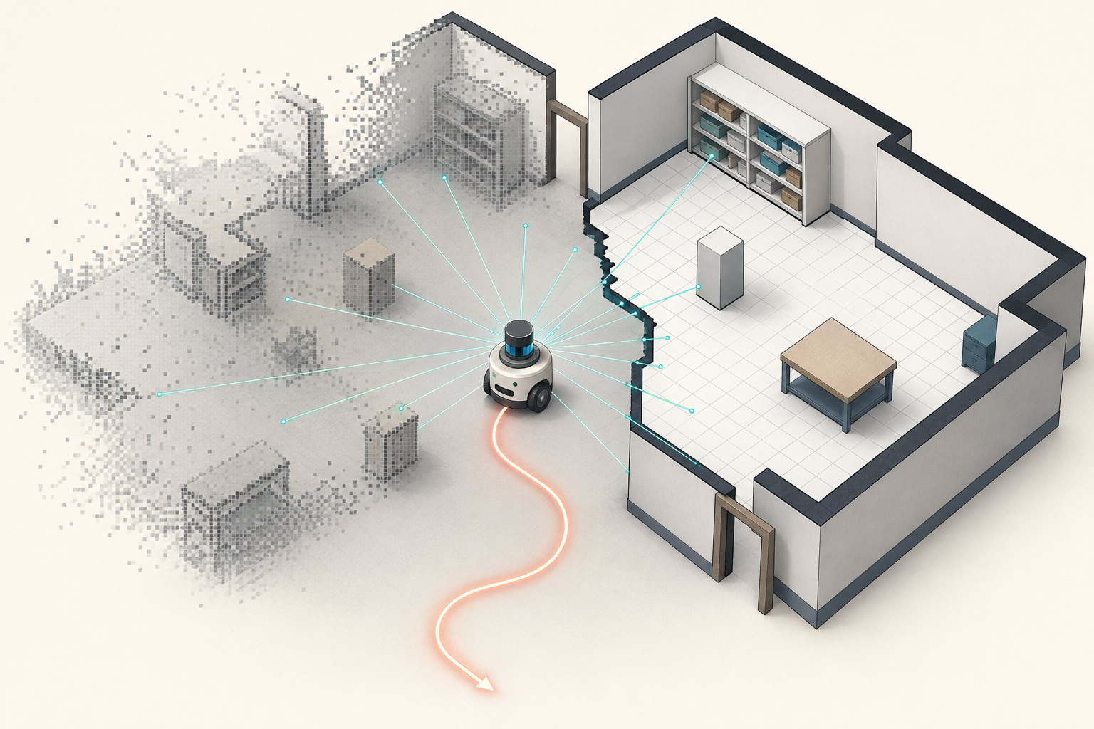
Key idea: SLAM is not a one-way pipeline that locates the robot first and maps second. It is a coupled estimation problem: an uncertain map helps estimate position, and that position is then used to update the map.
 ROS 2
ROS 2Image: Robot Operating System logo, Wikimedia Commons (CC BY-SA 4.0)

A SLAM System at a Glance
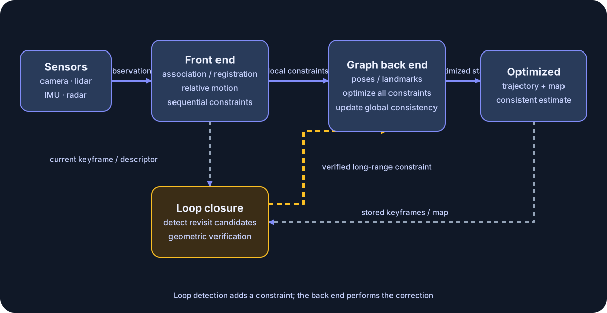
Diagram: Duskcoil. A representative graph-based SLAM system is simplified. Loop closure detects a revisit and adds a constraint; the graph back end corrects the trajectory and map. Component boundaries vary by implementation.
Even as SLAM methods change, their comparison axes remain legible. The front end forms correspondences and relative-motion constraints; the back end reconciles constraints across time; and loop closure adds a long-range constraint when a place is revisited. Learning-based methods replace part or all of these components, while 3DGS and NeRF primarily extend the map representation. The history below is easiest to follow as a story of how each of these parts has changed.
The First Current: Starting from Filter-Based Methods
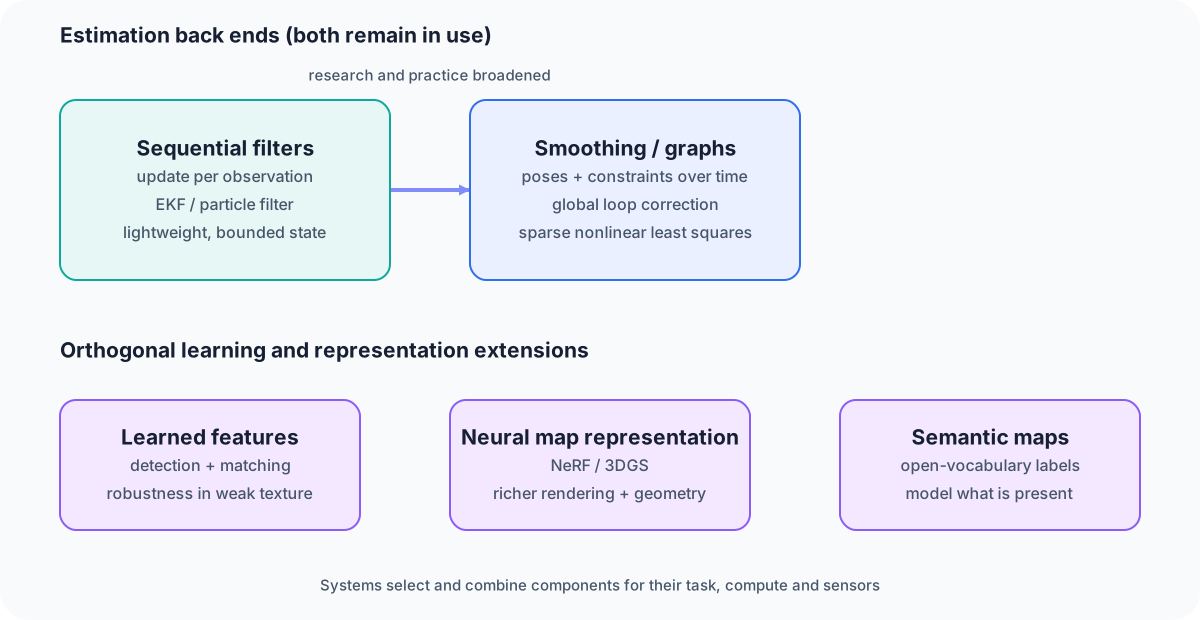
Diagram: Duskcoil. Changes in estimation and orthogonal extensions through learning, map representation, and semantics are separated. Older and newer methods still coexist and combine by application.
Early SLAM was dominated by sequential estimation via the Extended Kalman Filter (EKF) or particle filters — updating state every time a new sensor observation arrived. Computationally cheap, but with a weakness: error accumulates easily, and the approach tends to break down in large-scale maps.
The Second Current: The Shift to Graph Optimization
What became dominant after that was pose-graph optimization (graph SLAM). It builds a graph where each node is the robot's pose at some point along its trajectory, and each edge is a relative relationship derived from sensor observations, then optimizes the whole thing at once as a nonlinear least-squares problem. Combined with loop closure (recognizing a previously visited place and retroactively correcting accumulated error), this made it possible to build maps that hold up even in large-scale environments. slam_toolbox, used in newbot, belongs to this lineage. FAST-LIO instead performs tightly coupled LiDAR–IMU odometry with an iterated Kalman filter, rather than a pose graph.
What's Inside Graph Optimization: Formulated as Nonlinear Least Squares
Looking a bit more concretely at the problem graph SLAM is actually solving internally: it builds a graph where each node is the robot's pose at a point in time along its trajectory, and each edge is the relative positional relationship derived from sensor observations, and it's formulated as a nonlinear least-squares problem that adjusts every node's placement to be maximally consistent with every edge's constraint. Because sensor observations carry noise, the constraints between edges are bound to conflict with each other to some degree, and the role of this optimization is to distribute that conflict in the "least unreasonable" way possible.
Formally, for the full set of poses to be solved for, \mathbf{x} = (\mathbf{x}_1, \dots, \mathbf{x}_n), the problem is to minimize the following objective.
Here \mathcal{C} is the set of node pairs (edges) constrained by a sensor observation, \mathbf{e}_{ij} is the error function expressing the mismatch between node i and j's estimated poses and the sensor observation, and \Sigma_{ij}^{-1} is the weighting from that observation's confidence (the inverse covariance).
Iterative methods like Gauss-Newton or Levenberg-Marquardt are used to solve it. The error function is linearized around the current estimate (\mathbf{e}_{ij}(\mathbf{x} + \Delta\mathbf{x}) \approx \mathbf{e}_{ij}(\mathbf{x}) + \mathbf{J}_{ij}\Delta\mathbf{x}), and the normal equation \mathbf{J}^\top \mathbf{J} \, \Delta\mathbf{x} = -\mathbf{J}^\top \mathbf{e} is solved for the update \Delta\mathbf{x}, repeated until convergence. When the 3D positions of observed feature points (landmarks) are included as optimization targets alongside camera poses, this process specifically goes by the name Bundle Adjustment. SLAM problems have a large number of variables (poses, landmarks), but each individual observation only touches a small handful of them, so the resulting matrices (Jacobian, Hessian) come out sparse. Solving efficiently by exploiting that sparsity is the practical key here, and general-purpose optimization frameworks like Ceres Solver, g2o, and GTSAM are widely used as libraries for exactly this kind of sparse nonlinear least-squares problem.
The Third Current: Learning-Based, AI-Native SLAM
The current in progress right now is folding deep learning into the SLAM pipeline. Replacing explicit feature extraction and matching with deep learning is an active area of research aimed at improving robustness to lighting changes and texture-poor environments. More recently, a direction called "AI-native" or "semantic SLAM" has also emerged — integrating graph neural networks, or even large language models (LLMs) and Vision-Language-Action (VLA) models, into the SLAM pipeline. The goal isn't just "where am I" anymore, but building a semantic map that simultaneously understands "what's there."
A Shift in the Map Representation Itself
The most conspicuous recent change is a reinvention of the map's own "representation format." Beyond the traditional point cloud and occupancy grid, map representations built on Neural Radiance Fields (NeRF) and 3D Gaussian Splatting (3DGS) are rapidly gaining ground. These are increasingly outperforming traditional methods on mapping accuracy, rendering quality, and computational efficiency, and new 3DGS/NeRF-based methods — MHED-SLAM, GTS-SLAM, MTE-SLAM, HL-SLAM, PMET-SLAM, and more — have continued to appear at major conferences and journals well into 2026. See the separate article "Technology Trends in Visual-SLAM" for the details.
Late-2026 Snapshot: 3DGS-SLAM Diversifying by Domain
Looking concretely at the 3DGS/NeRF-based methods mentioned above through August 2026 publications, what stands out is how much the target domains have diversified. RoSe-SLAM builds semantically-tagged 3D Gaussian maps from monocular video in dynamic scenes (accepted to IROS 2026); Stipple, from Daniel Cremers' lab, incrementally builds a map in real time while tightly coupling visual and inertial data; GLAM-SLAM scales to city-block-sized environments through flow densification and spatial decomposition (also accepted to IROS 2026); and Real-Time LiDAR Gaussian Splatting SLAM combines LiDAR point clouds directly with 3D Gaussians. Specialization is proceeding along distinct axes — indoor vs. outdoor, dynamic scenes, large-scale environments. The approach is also spreading beyond robotics into medicine: EndoMD-SLAM targets endoscopic SLAM, and Track2Map (accepted to MICCAI 2026) targets laparoscopic surgery.
Integrating Semantic Understanding: Open-Vocabulary and Foundation-Model-Coupled SLAM
Digging further into the "learning-based, AI-native SLAM" current: 2026 has been the year multiple methods emerged that wire vision foundation model features directly into the SLAM pipeline. RADIO-ViPE (April 2026) tightly couples multi-modal embeddings from an agglomerative vision foundation model online, achieving open-vocabulary semantic SLAM that can localize arbitrary text-specified categories on the map even in dynamic environments. FeatureSLAM (January 2026) rasterizes features aligned with a vision foundation model onto each Gaussian in a 3D Gaussian Splatting map, building a semantically searchable map while preserving real-time performance. This direction is laid out systematically in the October 2025 survey "Semantic Visual SLAM: A Survey on State of the Art, Challenges, and Future Directions," which extends its scope all the way to large language model integration — underscoring how SLAM is shifting from pure geometric estimation toward systems that also carry semantic understanding.
Broadening Sensor Modalities: 4D Radar as an Option
Alongside LiDAR and cameras, research using 4D radar (millimeter-wave radar that provides range, azimuth, elevation, and Doppler velocity) as a third sensor modality — prized for its resilience to bad weather — continues to be actively updated. 4D Radar-Inertial Odometry, which combines 3D Gaussian modeling with multi-hypothesis scan matching, targets improved odometry accuracy in fog, rain, and dust conditions where cameras and LiDAR both struggle; first published in late 2024, it received a revised version as recently as March 2026. Benchmark datasets are also maturing toward more realistic operating conditions, as with the Hilti-Trimble-Oxford dataset (July 2026), which uses a 360-degree camera plus IMU and incorporates floor-plan priors.
Regional Patterns in Industry and Research
Analysis of SLAM-related patents and papers has pointed to China carrying a disproportionate weight in LiDAR-centric 2D SLAM, ROS-based implementations, graph optimization, and multi-robot/edge-computing research. Demand from practical applications — drones, service robots — appears to be strongly steering the direction of research.
Summary: The Three Currents Aren't Mutually Exclusive
Sequential filtering and graph optimization are choices for the estimation back end. Learned feature extraction, 3DGS/NeRF map representations, and semantic integration form separate axes that can combine with either. FAST-LIO, used in newbot for instance, is built on an iterated Kalman filter; FAST-LIO2 also registers raw points directly to the map without a separate feature-extraction stage. Which combination to choose depends on available compute, sensor configuration, and what the map is actually needed for — that's the practical conclusion at this point in time.
Does a new map representation solve every SLAM problem?
Appearance, localization, loop closure, and computation are separate dimensions. Identify the specific component a contribution improves.
References
- How NeRFs and 3D Gaussian Splatting are Reshaping SLAM: a Survey
- A Review on Visual-SLAM: Advancements from Geometric Modelling to Learning-based Semantic Scene Understanding (arXiv)
- Semantic Visual SLAM: A Survey on State of the Art, Challenges, and Future Directions (arXiv)
- RADIO-ViPE paper (arXiv)
- Hilti-Trimble-Oxford Dataset paper (arXiv)
- FAST-LIO2: Fast Direct LiDAR-inertial Odometry (arXiv)
- newbot's implementation is also covered in "How Self-Localization and Sensor Fusion Work" and "How Mapping and Autonomous Navigation Work"
Current step · 1 / 10 · Technology Trends
Comments
Please log in to post a comment
No comments yet.