Contents — find the section you need
Change parameters and verify
Open the panel, then press Run to load Python. You can stop execution and reset parameters. Results are computed on this device. No Python installation is required.
Local execution steps below are optional for reproducing the source results; they are not required for the browser experiment.
Background and reading guide
Background Units used in specifications, such as voltage, current, distance and time.
Fundamentals · Explanations of principles, structure and trade-offs.
Try in your browser: satellite geometry and error interpretation
Run the frozen synthetic observations in the Lab above. Save the spread-geometry result as A, then compare the clustered geometry. The XY and XZ panels project unit directions from the synthetic true receiver to each satellite, using the same fixed scale. These are teaching Cartesian projections, not a map or a real sky plot. Labels are satellite IDs 0–3; overlapping directions can overlap labels. The data table retains every direction component and error.
The original standard-library solver runs unchanged: four observations solve three position coordinates plus distance-equivalent receiver clock bias. Starting from all zeros, it performs at most 12 normal-equation updates, stopping when the maximum absolute update is below 10⁻⁸. Synthetic truth is (120, −80, 45) m with clock bias 1.25 m. A range-error increment d contributes satellite ID × d metres. Adjust d from 0 to 0.16 m in 0.01 m steps; the default 0.08 m replays the original CSV unchanged. This is deterministic error, not a noise standard deviation. The CSV ionosphere column was not added to the ranges by the original generator and is unused by this replay.
The spread case retains the original code name good, but both geometries are ill-conditioned. Its baseline z error is about −1819 m despite a nearly zero observation residual. With four observations, residuals cannot independently validate accuracy; the original solver also returns no convergence-success flag. The displayed 3D error is the distance to known synthetic truth. XY DOP uses the x/y diagonal entries of the inverse normal matrix in teaching coordinates, not geodetic HDOP after an ENU transformation. Read it alongside XYZ DOP; DOP does not rank the actual error of every individual observation set. These geometries are sensitive to rounding and do not measure receiver performance. See DOP and coordinate definitions (ESA Navipedia).
The lower two demonstrations are independent of the position solution. Vary TEC from 0 to 40 TECU to compare first-order code delays I=40.3×TEC×10¹⁶/f² at L1=1575.42 MHz and L2=1227.60 MHz with (f1²I1−f2²I2)/(f1²−f2²). Other errors and changes to observation noise after combining are not modeled. This follows the first-order ionosphere combination (ESA Navipedia). The common-error example simply subtracts a perfectly known common term c (−5 to 5 m) from c+e, leaving local error e (−1 to 1 m). It includes no carrier phase, double differencing or integer ambiguity resolution. The original package name rtk_baseline refers only to this idealized subtraction.
Use results JSON, shared conditions and the numerical table. A/B share axes within each panel, while separate panels use separate vertical scales. Original downloads and static results are preserved; local reproduction is optional. Save the browser entrypoint, original solver and synthetic CSV together to run with the Python standard library alone.
GNSS (Global Navigation Satellite System) is a sensor that computes a receiver's absolute position — latitude, longitude, and altitude — from the arrival-time differences of radio signals broadcast by multiple positioning satellites. "GNSS" is the umbrella term for constellations such as GPS (United States), GLONASS (Russia), Galileo (Europe), and Beidou (China); above Japan specifically, the Quasi-Zenith Satellite System "Michibiki" (QZSS) supplements GPS. Where a proprioceptive sensor like an IMU can only measure relative displacement and accumulates drift, GNSS's greatest strength is that it always outputs an absolute coordinate. But standalone positioning often carries errors of several meters, which alone is unusable for high-precision applications like autonomous driving or precision agriculture.
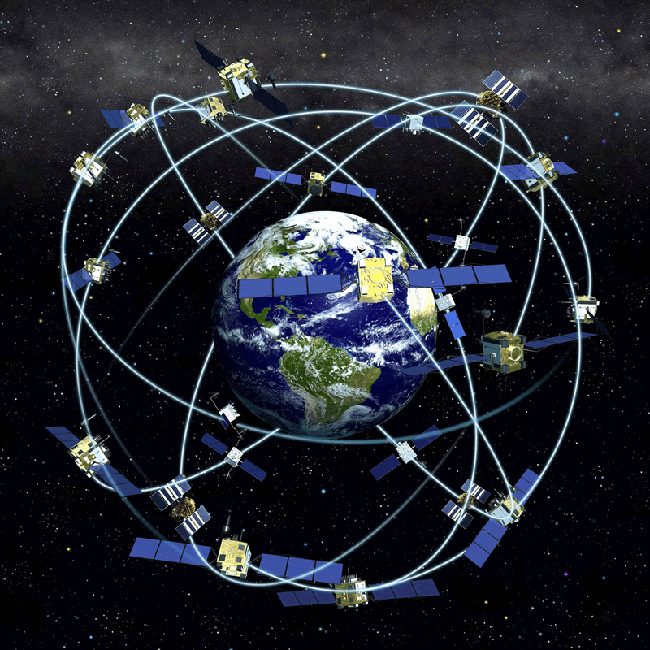 GPS satellite constellation
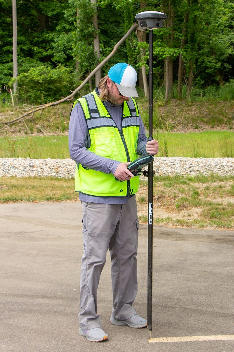 Survey work using an RTK-GNSS receiver
Images: GPS satellite constellation (U.S. National Oceanic and Atmospheric Administration, public domain) / Survey work using an RTK-GNSS receiver (Jacob Wysko, CC BY 4.0), Wikimedia Commons.


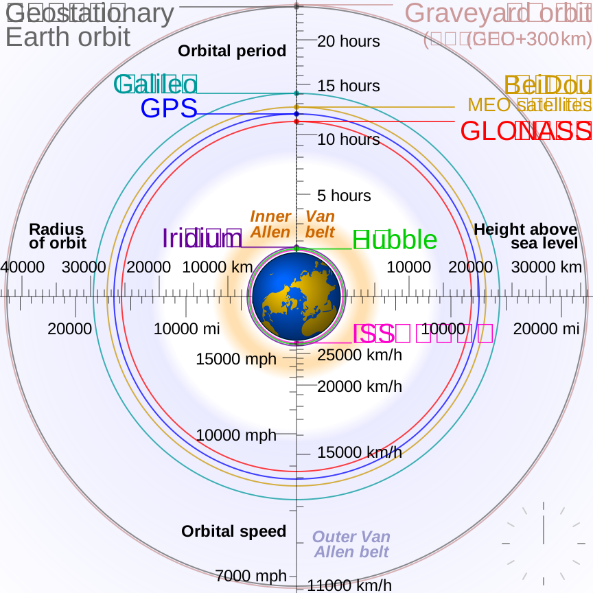
Image: Orbit comparison of GPS, GLONASS, Galileo, and Compass (Beidou), set against the International Space Station, Hubble Space Telescope, and geostationary orbit (cmglee, CC BY-SA 3.0 / GFDL), Wikimedia Commons. Every national GNSS constellation orbits in a medium-Earth orbit (MEO) at roughly 20,000 km altitude.

Principle: error sources in standalone positioning, and canceling ionospheric delay with dual frequencies
Standalone GNSS positioning (computing a fix using a single receiver alone) works by measuring the "pseudorange" to each satellite from radio signal travel time, then combining distances from multiple satellites via trilateration to solve for position. This pseudorange carries several stacked error sources.
Here R is the true geometric range between satellite and receiver, c(\delta t_r - \delta t_s) is the combined receiver/satellite clock error, I is ionospheric delay, T is tropospheric delay, M is multipath error (from signals reflecting off buildings or the ground), and \varepsilon is receiver observation noise. Of these, ionospheric delay I has a property worth exploiting: it is inversely proportional to the square of the carrier frequency.
TEC here is the electron-density integral along the signal path in electrons/m², f is in Hz, and I is in metres. One TECU is 10¹⁶ electrons/m². This positive term is the code group delay; the first-order carrier-phase term has the opposite sign. ESA Navipedia.
Because of this property, observing the same satellite on two or more distinct frequencies (L1 and L2, or L1/L2/L5) lets a receiver cancel out most of the ionospheric-delay component through calculation alone. This is why "dual-frequency positioning" has become the standard specification for high-accuracy GNSS receivers. Dual-frequency positioning can shrink standalone-positioning error to roughly a few meters, but tropospheric delay, multipath, and satellite-orbit errors remain — nowhere near centimeter-level accuracy on their own.
Principle: reaching centimeter-level accuracy with RTK
RTK (Real Time Kinematic) sets up a "base station" whose position is precisely known in advance, and has that base station transmit error information from its own satellite observations (carrier-phase measurements) to the "rover" — the receiver whose position we actually want — in real time. This cancels out error components common to both the base and the rover: ionospheric and tropospheric delay, and satellite orbit error. The closer the base and rover are to each other, the more correlated (and thus cancelable) those errors are, so RTK is typically only practical within roughly a dozen kilometers of the base station. With this correction, RTK shrinks the several-meter error of standalone GNSS positioning down to centimeter level.
An alternative approach that reaches centimeter-level accuracy from a single receiver, without a base station at all, is PPP (Precise Point Positioning). High-accuracy satellite orbit and clock corrections are distributed to the receiver via communication satellite or internet, trading a long convergence time (typically several minutes) for high-accuracy positioning with no base station required. Trimble's RTX (CenterPoint RTX) is a well-known example of "PPP-RTK," an evolution of PPP: it converges in under a minute in select regions and under three minutes worldwide, reportedly reaching 2 cm horizontal and 5 cm vertical accuracy (both RMS). Where RTK is bound by the coverage radius of its base station, PPP-RTK's strength lies precisely in wide-area or international deployments where building out a base-station network is impractical.
Comparing key products by spec
| Product | Category | Positioning accuracy (RTK/high-precision) | Supported constellations | Notable feature |
|---|---|---|---|---|
| u-blox ZED-F9P | RTK module IC | ~1 cm horizontal (RTK fix) | GPS/GLONASS/Galileo/Beidou/QZSS (concurrent reception) | The archetypal low-cost RTK module that drove widespread adoption across consumer and industrial applications alike |
| Septentrio mosaic-X5 | RTK receiver module | Centimeter-level | GPS/GLONASS/Galileo/Beidou/QZSS/NavIC (448 channels) | 31×31mm compact form factor with proprietary interference protection (AIM+) and multipath mitigation (APME+) |
| Trimble CenterPoint RTX | PPP-RTK correction service | 2 cm horizontal, 5 cm vertical (RMS) | Paired with a multi-frequency, multi-constellation receiver | High accuracy anywhere in the world with no base station required; converges in 1-3 minutes |
| John Deere StarFire 7500 (SF-RTK) | Agricultural machinery receiver | 2.5 cm horizontal | GPS/GLONASS/Beidou/Galileo | Reaches RTK-class accuracy via a correction signal with no additional hardware |
| Fixposition Vision-RTK 2 | Sensor-fusion positioning unit | 1.0 cm + 1 ppm, horizontal and vertical | GPS/GLONASS/Beidou/Galileo (dual dual-frequency receivers) | Fuses RTK with IMU and visual odometry; up to 200Hz output rate |
The u-blox ZED-F9P is arguably the single product most responsible for driving RTK-GNSS into surveying, agriculture, and robotics all at once, by bringing RTK-capable module pricing down into the low thousands of yen. It can receive GPS, GLONASS, Galileo, Beidou, and QZSS concurrently, and using SPARTN — u-blox's own correction-data format — accuracy on the order of 6 cm horizontal / 12 cm vertical has been reported. It ships in an L1/L2 variant and an L1/L5 variant, with the latter reportedly holding an advantage in "urban canyon" environments where tall buildings tend to obstruct satellite visibility. Septentrio's mosaic-X5 tracks every major constellation simultaneously across 448 hardware channels and carries proprietary interference- and multipath-mitigation technology, giving it an edge in the vibration- and RF-interference-heavy environments typical of UAVs and drones. The Fixposition Vision-RTK 2 fuses RTK positioning with IMU and visual odometry data, carries two dual-frequency receivers, and supports all four major constellations. Its 200Hz maximum output rate matters specifically for applications that need to track a fast-moving vehicle's attitude and position in real time.
The End of GPS's Deliberate Accuracy Degradation, and Michibiki's Permanent Perch Above Japan
GPS was originally developed by the U.S. military for military use, and even after civilian access was opened up, it carried a deliberately built-in feature called Selective Availability (SA) that intentionally injected error into the signal. While SA was active, a standalone civilian receiver's error could run as high as roughly 100 meters — a serious practical limitation. On May 2, 2000, following a decision by then-U.S. President Bill Clinton, SA was switched off, and civilian receiver error shrank overnight from ±100 m to roughly ±10-20 m. That change was made permanent in 2007, when procurement of the next-generation "GPS III" satellites — built without an SA capability at all — was formally decided. The few-meter-accuracy navigation we now take for granted on our smartphones simply would not exist without that 2000 policy change.
Japan has its own contribution to this story: the Quasi-Zenith Satellite System, "Michibiki" (QZSS). Its first satellite launched in September 2010, and a four-satellite constellation has been operating since November 2018. Michibiki's satellites fly what's called a "quasi-zenith orbit," a special orbit engineered so that at least one satellite is always positioned nearly directly overhead Japan (near the zenith). In Japan's terrain and dense urban environments, where tall buildings and mountains routinely block ordinary GPS satellites, a signal arriving from near the zenith is far less likely to be obstructed — meaningfully improving positioning stability alongside GPS. Michibiki also broadcasts a free centimeter-level augmentation signal called CLAS, which lets a compatible receiver reach centimeter-level accuracy with no additional base-station network at all.
GNSS does carry a known vulnerability, though: spoofing. Civilian GPS signals are neither encrypted nor authenticated, which in principle makes it possible to broadcast fake satellite signals and trick a receiver into computing a false position. Several arXiv papers published around 2025 (for example, arXiv:2506.08445, "GPS Spoofing Attacks on AI-based Navigation Systems with Obstacle Avoidance in UAV") document spoofing attacks inflating a UAV's estimated position error to over 20 meters, and flight controllers exhibiting unstable, oscillatory correction behavior as they react to falsified position feedback. The fact that GNSS cannot be unconditionally trusted to "always return the correct absolute coordinate" is not a minor footnote — it is a real design consideration in autonomous-vehicle and robot sensor-fusion architecture.
A real-world example: RTK-GNSS auto-steering in agricultural machinery
One of the fields where RTK-GNSS has become most thoroughly established in practice is agricultural machinery. Kubota has built out a nationwide RTK-GNSS base-station network — from roughly 40 sites as of January 2021 to 342 sites (including 82 installed by partner dealers) as of April 2024. RTK-GNSS makes precision auto-steering possible with an error of just ±2-3 cm, compared with ±10-15 cm for the simpler D-GNSS approach. In a case study from Aomori Prefecture, a positioning accuracy of roughly 2 cm was achieved within a 5 km radius of the base station.
Looking abroad, the largest agricultural-machinery maker, John Deere, has long offered its own "StarFire" correction signal. Its current StarFire 7500 receiver, paired with the "SF-RTK" correction signal, reportedly reaches horizontal accuracy on the order of 2.5 cm with no additional RTK base-station hardware to install. It also reports a convergence time (the time from power-on to reaching high-accuracy status) up to 73% shorter than the previous-generation SF3 signal — a striking contrast to Kubota's approach of building out its own base-station network, with John Deere instead substituting a distributed correction signal for that infrastructure. Yanmar also offers RTK-GNSS as an option on its Level 2 robotic tractors; achieving auto-steering precise enough to stay within a farm field's row spacing is exactly the kind of application where this several-centimeter accuracy level is not a luxury but a requirement.
Parameters that determine performance
- Positioning accuracy (whether RTK/PPP correction is used): The gap between D-GNSS (±10-15 cm) and RTK-GNSS (±2-3 cm) becomes decisive in applications like agricultural-machinery auto-steering, where the required precision is measured in centimeters relative to the size of the target (a crop row)
- Distance from the base station, or choosing a PPP approach instead: RTK's correction effectiveness fades with distance from the base station (roughly 5 km radius / ~2 cm accuracy in the Aomori case study above). Kubota's expansion from roughly 40 to 342 base stations reflects exactly this constraint — every farm field needs to fall within some base station's coverage. Where building out a base-station network is impractical — remote regions, international deployment — a PPP-RTK approach like Trimble RTX becomes the alternative
- Convergence time: PPP-RTK needs no base station, but pays for it with a "convergence time" of tens of seconds to several minutes from power-on to reaching high-accuracy status. RTK converges quickly as long as it can continuously receive correction data from its base station. John Deere's marketing around a 73% shorter convergence time versus its previous generation reflects how directly convergence time drives real-world usability
- Maximum output rate: A higher update rate — 200Hz for the Fixposition Vision-RTK 2, 100Hz for the Septentrio mosaic-X5 — lets the system track a fast-moving vehicle's position with less lag. For slow-moving agricultural machinery, this high a rate is not always necessary
- Number of supported constellations and frequencies: Supporting four constellations and dual (or, as with the mosaic-X5, multiple) frequencies increases the number of satellites a receiver can capture, making it easier to sustain a fix in environments where some satellites are obstructed — dense urban high-rises, or the metal framing of a greenhouse. Within Japan specifically, whether a receiver supports Michibiki (QZSS) is itself a practical differentiator
- Whether sensor fusion is used: GNSS alone loses its fix in tunnels or behind buildings with poor sky visibility. Integrating it with IMU and visual odometry — as the Fixposition Vision-RTK 2 does — lets the system keep estimating position for a short period even when the GNSS signal is briefly lost
- Robustness against spoofing and jamming: Civilian GPS signals are unencrypted and vulnerable to spoofing attacks. Interference-mitigation features like Septentrio mosaic-X5's AIM+ become a real selection criterion for applications where this threat is a practical risk — security and defense-adjacent work, or monitoring critical infrastructure
Estimating position error with DOP
A specification such as “2 cm horizontal” assumes good satellite geometry, stable corrections, and little multipath. For a first design estimate, separate the range-measurement error from the amplification caused by satellite geometry. If the standard deviation of a range observation is \sigma_\rho and the geometric amplification is DOP (Dilution of Precision), a first-order approximation is
This approximation assumes a linearized code-positioning model with independent, equal-variance observation errors. For standalone positioning, σρ=0.5 m and HDOP=1.5 give a horizontal error scale of about 0.75 m. RTK requires a covariance model that includes carrier ambiguities, correlated differenced observations and correction state; replacing code noise with a phase residual does not guarantee positioning accuracy.
Figure — Even with the same range noise, poor satellite geometry (large DOP) amplifies position error. The lines are conceptual, not measured curves.
Do more visible satellites guarantee accurate GNSS?
Geometry, multipath, blockage, and correction quality also matter. Check residuals, solution status, and measured error.
Experiment: solving receiver state from pseudoranges
The principles above can be exercised with a small synthetic experiment—not as a claim about real receiver accuracy. N03 GNSS Lab estimates a receiver's x,y,z position and distance-equivalent clock bias by iterative least squares from four fixed satellites and code pseudoranges in Cartesian metres. It omits satellite clocks, ionosphere, troposphere, multipath, Earth rotation, and carrier-phase ambiguities used by RTK.
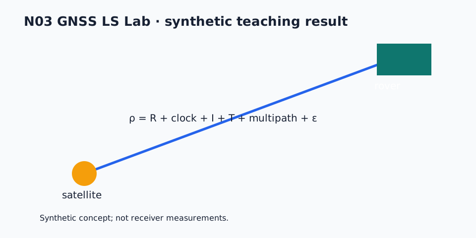
The frozen synthetic.csv, results.json, and manifest.json record the data, results, and SHA-256 hashes. The package uses only the Python standard library; download the reproducibility ZIP, README, manifest, and source here:
The poor-geometry plot is an intentional teaching case. Its very large DOP must not be read as receiver performance or as a real-world error bound. The signs, units, and interpretation of DOP follow the definitions in this article.
References
- Fixposition Vision-RTK 2 product page
- How Kubota's RTK-GPS base stations work (Kubota official)
- Kubota's nationwide RTK-GNSS base-station rollout (Nikkan Kogyo Shimbun)
- u-blox ZED-F9P module product page
- u-blox ZED-F9P datasheet (u-blox official PDF)
- Septentrio mosaic-X5 product page
- Trimble CenterPoint RTX product page
- Trimble RTX correction services FAQ (Trimble official PDF)
- John Deere StarFire 7500 (SF-RTK) overview (Cornthwaite Group)
- History of GPS Selective Availability's removal (GPS.gov official)
- Quasi-Zenith Satellite System Michibiki overview (Cabinet Office QZSS official)
- Michibiki first satellite overview (JAXA official)
- GPS Spoofing Attacks on AI-based Navigation Systems with Obstacle Avoidance in UAV (arXiv:2506.08445)
Comments
Please log in to post a comment
No comments yet.