Contents — find the section you need
Background and reading guide
Background Basic force, motion and energy terminology; use the linked background explanations.
Fundamentals · Explanations of principles, structure and trade-offs.
0. What this article explains
- What an HD (High Definition) map stores that an ordinary navigation map does not.
- How lane centerlines, topology, traffic rules, and semantic layers feed perception and planning.
- How it differs from a sensor-built SLAM map, with a localization objective, update limits, and operational safeguards.
1. Bottom line: what is an HD map?
An HD map records a road not merely as a route to follow, but as a lane-level database of boundaries, centerlines, connectivity, signs, stop lines, grade, and other semantics at a precision useful for driving decisions. An autonomous vehicle does not blindly trust it: it compares the map with cameras, LiDAR, radar, and GNSS, while carrying map version and uncertainty into the decision.
2. Why an ordinary map is not enough
A navigation road link only needs connectivity and travel time between junctions. Lane changes and stopping before a stop line require road width, lane count, turn-only lanes, crosswalks, and occluding structures. A temporary closure illustrates the problem: the road link is unchanged, but the drivable region and lane topology are not.
Static information in an HD map can announce a lane or merge hidden beyond a crest or curve. Pedestrians and queues that change in seconds should remain perception and behavior-planning outputs rather than static map objects. Confusing that boundary lets stale data interfere with safety decisions.
3. Inputs: survey vehicles and field sensors
Map production combines RTK-GNSS/INS trajectories with cameras, LiDAR, wheel odometry, and sometimes aerial survey. LiDAR points are segmented into pavement, curbs, and signs; images verify sign classes and markings; repeated drives help remove temporary objects. If the survey trajectory is less accurate than a lane width, no downstream localization trick can recover the lost accuracy.
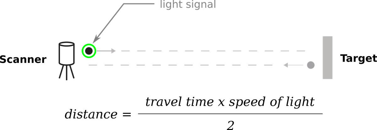 Using ranging to build a map
Image: Duskcoil's existing LiDAR-principle figure. Production HD mapping also requires time synchronization, extrinsic calibration, and multi-drive registration.
4. Output: a semantic road graph
The core separates geometry (where) from topology (what connects to what). If a lane centerline is represented as \mathbf{r}(s)=[x(s),y(s)]^\mathsf{T} parameterized by arc length s, its curvature is
The lateral acceleration required at speed v is a_y=v^2|\kappa|. A planner can therefore evaluate speed limits and comfort along a curve rather than merely trace a line.
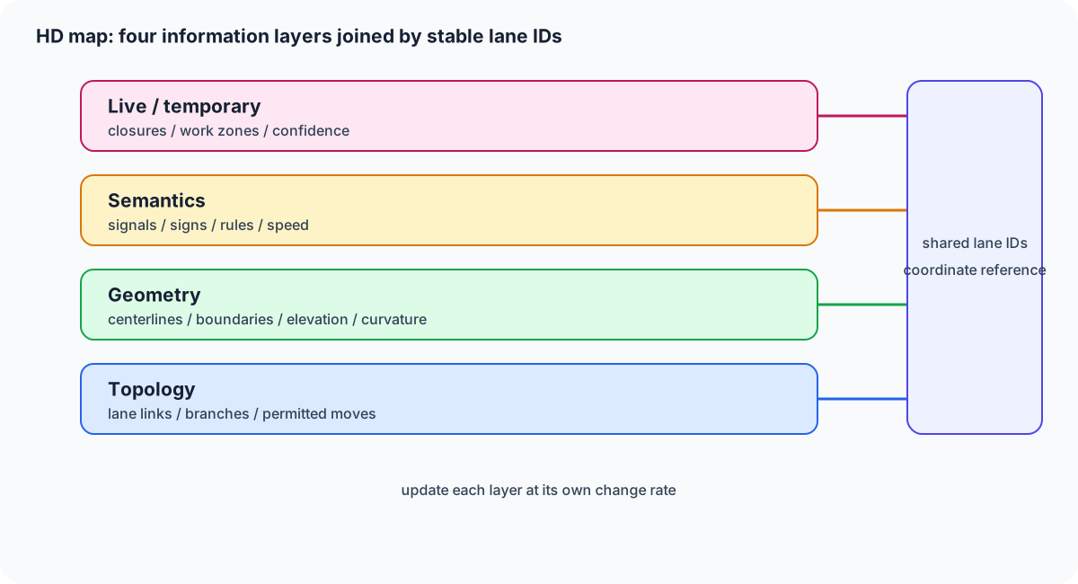
Figure 1 — Separate topology, shape, semantics, and temporary information. This makes it possible to update one layer without rebuilding every lane connection.
5. Basic pipeline: put map and observations in one frame
ASAM OpenDRIVE is an exchange format for road-network geometry and lanes in simulation, while NDS defines data standards spanning in-vehicle navigation and automated driving. Despite format differences, the implementation flow is the same: stream a map tile, transform it into the vehicle frame, align observations, and pass the result to planning.
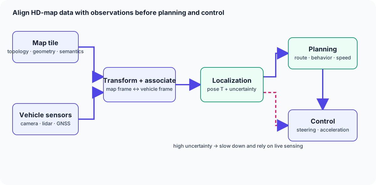
Figure 2 — Localization fuses the HD map with vehicle sensors before behavior planning and control. When map confidence is low, the vehicle should slow down and rely more on live sensing.
6. Localization mathematics and the SLAM connection
Let vehicle pose be \mathbf{T}\in SE(2), a map feature be \mathbf{m}_i, and a sensor observation be \mathbf{z}_i. With known correspondences, robust alignment can be written as
\pi projects a map feature into sensor coordinates, \Sigma_i is measurement covariance, and \rho limits the effect of outliers. Absolute GNSS position, LiDAR road shape, and camera lane boundaries can then participate in one estimator.
SLAM estimates an unknown map and pose together. HD-map use is localization against a known static map. In practice, detecting changes and building a local replacement for a changed tile still needs SLAM-like remapping. Treating the map as versioned prior information with uncertainty is safer than treating it as a finished truth.
7. HD map versus a SLAM map
| Aspect | HD map | SLAM map |
|---|---|---|
| Main purpose | Preview road rules and geometry for planning | Estimate pose while building an unknown map |
| Coordinates | Geodetic, lane, and elevation frames | Often local frame anchored at sensor start |
| Semantics | Lanes, signs, stop lines, right of way | Primarily points, features, and geometry |
| Updates | Cloud editing, versioned delta distribution | Incremental updates from current observations |
| Weakness | Construction, snow, and stale data | Long-term drift and place recognition |
HD maps provide foresight; SLAM provides local current pose. The interface must document coordinate frame, timestamp, and vertical datum (ellipsoid height versus elevation). A frame mismatch of a few tens of centimeters can change lane selection on a narrow road.
8. Failure modes and difficult environments
- Construction and temporary control: a changed lane connection cannot be fixed by a static tile alone. Distribute observed-but-unapproved deltas and reduce speed until validation.
- Snow, leaves, and wet pavement: markings and LiDAR returns change. Combine seasonal observations with a perception layer that outranks missing map objects.
- Urban canyons and tunnels: GNSS degrades and repeated walls create geometric degeneracy. Use lane boundaries, IMU, and wheel odometry as short-term aids.
- Freshness: an accurate old map can be more dangerous than an uncertain current observation. Store collection time, validation time, coverage, and confidence on every layer.
9. Practical choices and update design
- Motorways: prioritize lane centerlines, merges, splits, curvature, and grade. Test cache consistency and cloud delta delivery over a long look-ahead distance.
- Urban automated driving: represent stop lines, crosswalks, signal lanes, and turn rules semantically; when map and observation disagree, live observation wins.
- Delivery robots: use a sidewalk-specific layer for width, steps, ramps, and restrictions rather than reusing a road HD map. Update rate and passability can matter more than centimeter accuracy.
- Simulation: exchange road geometry and lane connectivity through ASAM OpenDRIVE, while keeping production semantics separate from test scenarios.
Log tile ID, version, creation time, validation time, allowed speed, confidence, and revocation state. Define the last-known-good cache, sensor-only degradation mode, and stop condition before the map server becomes unavailable.
10. Three-line recap
An HD map is a semantic road graph containing lane-level geometry and traffic meaning.
Localization fuses it with vehicle sensing so planning can see beyond current visibility, while SLAM supplies local pose.
Construction, snow, and staleness require versioning, confidence, and a rule never to trust the map blindly.
Does a precise map reveal current obstacles?
Objects appearing after the last update may be absent. Combine map priors with current sensor observations.
References
- ASAM OpenDRIVE specification
- Navigation Data Standard Association
- HERE HD Live Map product sheet
- A Common Map Data Standard for Autonomous Driving (NDS white paper)
- Automatic Construction of Lane-level HD Maps for Urban Scenes (arXiv:2107.10972)
- UK Government: location data for connected and automated mobility
Current step · 4 / 5 · Connected & Autonomous Driving
Comments
Please log in to post a comment
No comments yet.